Synopsis
The A-Z Mini Map series is the perfect combination of detailed large scale city or town centre mapping folded into a compact 105mm x 65mm pocket sized cover.
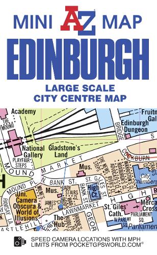
This A-Z map of Edinburgh City Centre is a full colour, double-sided, A3 fold-out mini map.
Side one features a large scale street map of central Edinburgh, shown at a clear 10.33 inches to one mile (16.32 cm to 1 km), which extends to include:
•Edinburgh Castle
•The Scottish Parliament Visitor Centre
•Princes Street & Edinburgh Waverley railway station
•National Museum of Scotland
•Edinburgh's Royal Mile
•The Palace of Holyroodhouse
The reverse side features:
•Large scale street map index listing streets, selected flats, walkways, selected places of interest and hospitals
•Street map of Leith Docks featuring the location of Britannia (the former royal yacht)
•Location map of the University of Edinburgh (King's Buildings)
•A road map of the Edinburgh area
•Reference panel
A & B roads, minor roads, one-way streets, safety camera locations with maximum speeds, selected places of interest and a wide range of ancillary information are featured on the street mapping.
This pocket sized mini map of Edinburgh is ideal for residents, students and visitors wishing to explore this historic and cultural city, the capital of Scotland.
Publisher information
- Publisher: HarperCollins Publishers
- ISBN: 9781782570936
- Number of pages: 1
- Dimensions: 105 x 65 x 5 mm
- Weight: 18g
- Languages: English
Customer Reviews
You may also like...