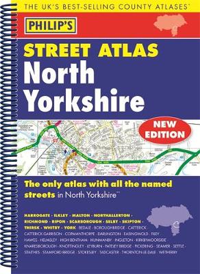
Philip's Street Atlas North Yorkshire
Synopsis
THE ONLY COUNTY STREET ATLAS WITH ALL THE NAMED STREETS OF NORTH YORKSHIRE,
The UK's best-selling county street atlases
More than 24,000 named streets, roads, lanes and alleys
The essential map books for residents and visitors - and if you're moving to North Yorkshire
Includes all the streets in HARROGATE, ILKLEY, MALTON, NORTHALLERTON, RICHMOND, RIPON, SCARBOROUGH, SELBY, SKIPTON, THIRSK, WHITBY, YORK, BEDALE, BOROUGHBRIDGE, CATTERICK, Catterick Garrison, Copmanthorpe, Darlington, Easingwold, Filey, Hawes, Helmsley, High Bentham, Hunmanby, Ingleton, Kirkbymoorside, Knaresborough, Knottingley, Leyburn, Pateley Bridge, Pickering, Seamer, Settle, Staithes, Stamford Bridge, Stokesley, Tadcaster, Thornton-le-Dale, Wetherby.
- New edition in practical spiral-bound format
- Street maps show car parks, schools, hospitals and many other places of interest, even ones off the beaten path
- 4-page practical route-planning section showing all A and B roads
- Super-clear mapping
- Easy-to-use index
- Scales: 13/4 inches to 1 mile (1:36,000) and 31/2 inches to 1 mile (1:18,000). Major towns: 7 inches to 1 mile (1:9,000).
Other information on the maps includes postcode boundaries, car parks, railway and bus stations, post offices, schools, colleges, hospitals, police and fire stations, places of worship, leisure centres, footpaths and bridleways, camping and caravan sites, golf courses, and many other places of interest.
Publisher information
- Publisher: Octopus Publishing Group
- ISBN: 9781849073684
- Number of pages: 288
- Dimensions: 266 x 198 x 18 mm
- Weight: 540g
Customer Reviews
You may also like...