
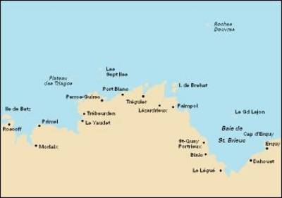
Imray Chart C14: Cap D'erquy to Ile De Batz
Map Published on: 01/12/2009
Price: £18.00
Synopsis
Plans: Primel Riviere Le Leguer Trebeurden Ploumanac'h Anse de Perros Perros-Guirec Port-Blanc Approaches to Riviere de Treguier Treguier Approaches to Riviere de Trieux and Paimpol Port de la Corderie (Ile de Brehat) Port Clos (Ile de Brehat) Lezardrieux Paimpol St-Quay-Portrieux Binic Port du Legue Dahouet 2009 edition includes extensive updating throughout. Some areas of the chart redrawn to improve positional accuracy. Includes latest depths in Anse de Perros and the approaches to Le Trieux. Buoyage in the approaches to Riviere de Treguier and Le Legue fully updated.
Publisher information
- Publisher: Imray,Laurie,Norie & Wilson Ltd
- ISBN: 9781846232480
- Dimensions: 297 x 210 x 5 mm