

Imray Chart Pack 2500 2014: Channel Islands
Synopsis
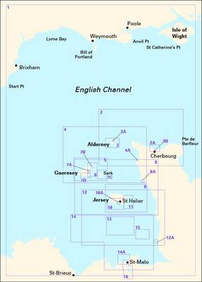
A completely revised edition of the 2500 chart pack, now consisting of 9 double-sided sheets to cover the Channel Islands and adjacent coast of France in detail. This replaces the old edition and component charts of 2500 The Channel Islands which are no longer supported by corrections. The pack consists of the following: 2500.1 Approaches to the Channel Islands (1:500,000) 2500.2 Cap Barfleur to Alderney (1:150,000) A Cherbourg (1:40,000) B Port de Chantereyne (Cherbourg) (1:10,000) 2500.3 Alderney & Burhou (1:25,000) A Alderney Harbour (1:12,500) 2500.4 Passages between Alderney & Guernsey (1:150,000) A Dielette (1:15,000) 2500.5 Guernsey, Herm & Sark (1:60,000) 2500.6 East Guernsey & Herm (1:25,000) 2500.7 Guernsey & Sark Plans A St Peter Port & Havelet Bay (1:6,000) B Beaucette Marina (1:10,000) C Sark Anchorages (1:25,000) D Guernsey - South Coast Anchorages (1:25,000) 2500.8 Passages between Guernsey & Jersey (1:150,000) A Carteret (1:25,000) 2500.9 Jersey & Les Ecrehou (1:75,000) 2500.10 Approaches to St Helier (1:30,000) A St Helier Harbour (1:15,000) 2500.11 East Coast of Jersey (1:25,000) 2500.12 Jersey to Granville (1:150,000) A Granville (1:20,000) 2500.1
3 Plateau des Minquiers (1:50,000) 2500.14 Plateau des Minquiers to St-Malo (1:150,000) A St-Malo (1:55,000) 2500.15 Illes Chausey (1:30,000) 2500.16 St-Malo & La Rance (1:15,000) includes continuation to Lyvet (1:25,000)
Publisher information
- Publisher: Imray, Laurie, Norie & Wilson Ltd
- ISBN: 9781846236129
- Number of pages: 15
- Dimensions: 420 x 490 x 4 mm
Customer Reviews
You may also like...