
Imray Chart Pack 2600: Bristol Channel
Map Published on: 01/12/2011
Price: £39.50
Synopsis
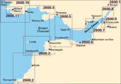
Trevose Head to St David's Head including the River Severn A pack of 11 charts covering the Bristol Channel. The pack includes: 2600.1 Trevose Head to St David's Head 1:450,000 2600.2 Padstow to Hartland Point 1:120,000 2600.3 Hartland to Ilfracombe 1:130,000 2600.4 Approaches to the Bristol Channel 1:130,000 2600.5 Ilfracombe to Nash Point 1:130,000 2600.6 Nash Point to Flat Holm 1:80,000 2600.7 Flat Holm to Avonmouth 1:70,000 2600.8 River Severn to Sharpness 1:50,000 2600.9 River Avon 1:20,000 2600.10 Tenby to Skomer Island 1:350,000 2600.11 Milford Haven to River Cleddau 1:30,000
Publisher information
- Publisher: Imray, Laurie, Norie & Wilson Ltd
- ISBN: 9781846234095
- Number of pages: 11
- Dimensions: 594 x 420 x 4 mm