
Synopsis
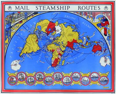
Commissioned by the General Post Office in 1937, by the time MacDonald Gill completed 'Mail Steamship Routes' he was already a renowned designer and illustrator. This bright and lively world map depicts the Royal Mail steamship routes that carried the majority of the UK's international mail during the 1930s, framed by some delightful illustrations of the transport links through which the post would pass. A series of eleven images tracing the development of sailing vessels from the time of King Alfred to the RMS Queen Mary is bound to appeal to enthusiasts of maritime history, and also included is an introduction by an employee of the British Postal Museum Archive. (Map measures: 620 x 768mm)
Publisher information
- Publisher: Bloomsbury Publishing PLC
- ISBN: 9781908402264
- Dimensions: 848 x 700 x 8 mm
- Weight: 357g
Customer Reviews
You may also like...

The Plimsoll Sensation
Price: £12.99

Nelson
Price: £14.99
Titanic Voices
Price: £22.00
Jack Tar
Price: £14.99

The Command of the Ocean
Price: £20.00
The Levelling Sea
Price: £12.99

Lost Voices from the Titanic
Price: £15.99
The Bounty
Price: £16.99

A Night to Remember
Price: £10.99

The Lighthouse Stevensons
Price: £12.99

The Last Grain Race
Price: £12.99

Over the Edge of the World
Price: £14.99

Pirates Of Barbary
Price: £12.99

Ship Spotter’s Guide
Price: £6.99
Empires of the Sea
Price: £12.99